Download
Istanbul Subway Map: A Guide to Navigating the City
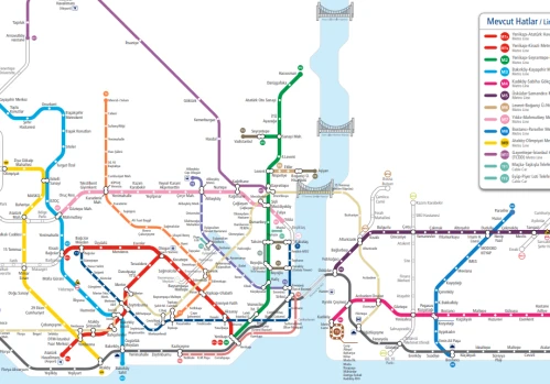
Istanbul, a city that bridges Europe and Asia, is home to one of the fastest-growing metro networks in the world. The Istanbul Subway Map is an essential tool for both locals and visitors, providing a clear overview of the city’s complex yet well-organized metro system. With millions of daily commuters, the metro has become a vital part of Istanbul’s public transportation network.
Overview of the Metro System
The Istanbul Metro currently consists of multiple lines, each marked with distinct colors and numbers on the map. These lines connect major districts, business centers, residential areas, and tourist attractions. The metro system integrates with other forms of public transportation, such as trams, buses, ferries, and the Marmaray rail line, making it possible to travel across the city efficiently.
Key Metro Lines on the Map
M1 Line (Red): One of the oldest lines, connecting Atatürk Airport (formerly) and Aksaray, serving the western districts.
M2 Line (Green): Runs between Yenikapı and Hacıosman, covering important stops like Taksim, Levent, and Şişhane.
M4 Line (Pink): Located on the Asian side, it links Kadıköy with Sabiha Gökçen Airport, making it crucial for travelers.
M5 Line (Purple): A fully automated driverless line operating between Üsküdar and Çekmeköy.
M11 Line (Dark Green): Connects the new Istanbul Airport with the city, providing a direct and modern travel option.
Importance of the Subway Map
The Istanbul Subway Map is more than just a guide; it is a lifeline for navigating a city with nearly 16 million residents. Tourists rely on it to reach landmarks like the Grand Bazaar, Sultanahmet, and Bosphorus districts, while residents use it daily to commute to work and school. The map is designed to be user-friendly, with bilingual labels in Turkish and English, ensuring accessibility for international travelers.
Future Expansions
The Istanbul Metro network is constantly expanding. New lines and extensions are under construction to reduce traffic congestion and provide faster connections between the European and Asian sides of the city. As the map evolves, it reflects the city’s growth and modernization.
Conclusion
The Istanbul Subway Map is a symbol of the city’s dynamic character. It combines tradition and modernity by connecting ancient neighborhoods with new urban centers. Whether you are a visitor exploring Istanbul’s rich history or a local commuting across the Bosphorus, the subway map is an indispensable companion that makes traveling around this vibrant city easier and more efficient.
Populer Blogs
How to Get and Use the Istanbul Card - Istanbulkart
If you're visiting Istanbul, one of the most essential tools for navigating the city is the Istanbul Card (Istanbulkart). This contactless smart card is the most convenient and cost-effective way to use public transportation
Istanbul Subway Map
Istanbul, a city that bridges Europe and Asia, is home to one of the fastest-growing metro networks in the world. The Istanbul Subway Map is an essential tool for both locals and visitors,